Did You Know?

Boston: England’s Medieval Gateway to the World
 During the 13th and 14th centuries, Boston was the second busiest port in England after London [1]. As a member of the Hanseatic League, Boston was a prosperous hub for international trade and hosted renowned annual fairs that attracted merchants from across Europe. Those traders from modern day Germany, Poland, Scandinavia, the Low Countries and the Baltic brought a distinct cosmopolitan character to the town.
Plague and Peril: How the Black Death Devastated Rural Lincolnshire
From Boston to the New World: The Pilgrims' Journey and Legacy
 In 1607, a group of separatists attempting to escape the country in search of religious freedom was arrested at Scotia Creek (near Fishtoft) and held at Boston’s Guildhall after being betrayed by their ship’s captain. This group later became known as the Pilgrims, and they eventually did succeed in fleeing to the Netherlands before embarking upon their historic 1620 voyage to the New World aboard the Mayflower, setting sail from Plymouth [1]. Their legacy was continued in 1630 when almost a third of the town’s citizens left Boston on the Arbella for America, eventually founding a new settlement: Boston, Massachusetts [2]. You can still visit the cells at the Guildhall – check out here.
Wild West Comes to Boston
Boston’s Coastal Haven: A Vital Stop for Migratory Birds
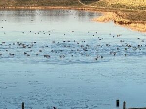
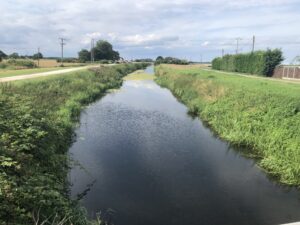
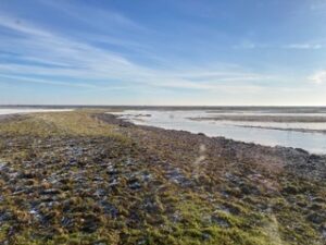 Boston’s coastal area, the Wash, is an internationally significant wetland that serves as a habitat to over 16 species of migratory birds [1]. This coastal region is essential for those birds, and offers crucial feeding areas prior to their long migrations to Europe and Africa. Recognised as a Special Area of Conservation, the Wash is a key international site for wildlife protection.
Fydell House: A Georgian Mansion with a Global Legacy
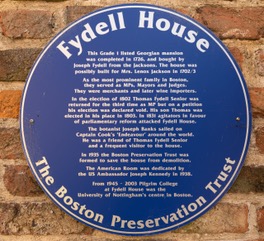
 Fydell House, a stunning Queen Anne town house located within Boston’s Cultural Quarter, was built around 1706. It takes its name from the Fydell family who lived there after 1726; Joseph Fydell was a prominent local merchant and politician [1]. Notable visitors included botanist Sir Joseph Banks, who sailed on Captain Cook’s HMS Endeavour and played a pivotal role in global exploration [2]. In 1938, the American Room was dedicated by US Ambassador Joseph Kennedy, further emphasising the town’s transatlantic connections [3]. You can visit the website for more information.
Enclosure and the Transformation of the Fens
 In the 18th and 19th centuries, the enclosure and subsequent drainage of the Fens transformed marshy lands into fertile farmland, significantly boosting agricultural productivity in Lincolnshire. This was part of the broader Agricultural Revolution which introduced new farming techniques to food production. These changes faced substantial resistance from local communities who relied on common land for grazing and resources. Protests and riots erupted, particularly in the 1760s and 1770s, as Fenland inhabitants opposed the loss of their traditional livelihoods [1]. Despite this opposition, the enclosures were largely completed by 1815, leading to increased agricultural efficiency but also social unrest and displacement [1].
George Bass: Boston's Explorer of the Bass Strait
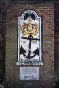 George Bass (1771 – 1803) was a naval surgeon and explorer who made significant contributions to the exploration of Australia. He studied at Boston Grammar School before pursuing medical training at the hospital in Boston, and joined the Royal Navy in 1794 as a surgeon [1]. Owing to his travels, the body of water separating Tasmania from mainland Australia, Bass Strait, is named after him. A plaque commemorates his legacy at the site of the former Crown & Anchor Tavern on London Road [2].
 Irish Town: Boston’s Resilient Immigrant Community
Boston’s Maritime Icons: Ships with Remarkable Histories
The Jolly Sailor: A Maritime and Wartime Landmark
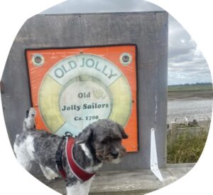
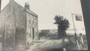 The Jolly Sailor, once a bustling pub in Freiston Shore, was a meeting point for farmers, fishermen, and sailors. It acted as a crucial landmark for people coming to and from the town as they sailed down the river. In the 1940s, it stood near a coastal gun emplacement, part of the Boston Examination Battery, that had been built to defend against potential wartime invasions [1]. During World War II, the pub also served as a navigational aid for the RAF. After its closure as a pub in the 1950s, it was converted into a private residence [2]. Today, it stands as a testament to the area’s rich maritime and wartime history.
Boston's Second Wave of Prosperity
 In the 18th and 19th centuries, Boston experienced a second wave of prosperity. As the River Haven silted up, trade shifted to ports such as Bristol and Liverpool. However, from 1760 to 1860, locally-based industries such as shipbuilding, flour milling, canning, and featherbed manufacturing thrived [1]. The drainage of the fens, increased agricultural productivity, and improvements in transport – including the railway station that was opened in 1848 – provided new markets for trade.
Boston’s Industrial Evolution
In the 19th and 20th centuries, industrialisation in Boston focused on agricultural machinery, breweries, tanneries, and feather production, but it was also known for innovations in labelling. Norprint Ltd, established in the 1960s, became a global leader in self-adhesive labels and prepaid magnetic passes; revolutionising public transport ticketing worldwide. The company, Boston’s largest private employer with 800 staff, supplied tickets for the London Underground, New York Metro, and Sydney Rail. By 1995, it had diversified into rail, airline, and supermarket labels before sadly entering administration in 2015 [1].
During the War
Viking Roots: Boston's Place Names
The village names Skirbeck and Fishtoft near Boston reflect the area’s Scandinavian heritage. “Skirbeck” derives from Old Norse, combining “skírr” (bright or clear) and “bekkr” (stream), indicating a “bright stream” [1]. The origin of “Fishtoft” is less certain; while “toft” is a Norse term for a homestead or plot of land, the significance of the “Fish” prefix remains unclear [2]. These place names highlight the lasting impact of Viking settlers in the region.
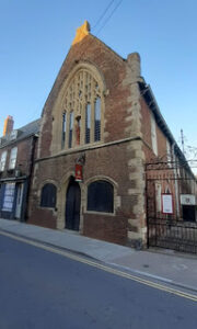
Boston’s Egyptian-Inspired Freemasons’ Hall
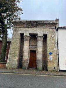 Boston’s Freemasons’ Hall, built between 1860 and 1863, showcases a striking Egyptian Revival portico. Inspired by the Temple of Dendur in Nubia, this unique feature stands out against the building’s otherwise simple brick exterior [1]. The ornate entrance is framed by a steeply battered doorway, topped with a winged sun and a Greek inscription reading “Know Myself” [1]. This architectural nod to ancient Egypt reflects the 19th-century fascination with Egyptian design, and adds an exotic touch to the local urban landscape.
A Port in Wartime
During World War I, Boston’s docks played a pivotal role in the exchange of British and German Prisoners of War. During 1917-18, the port facilitated the repatriation of thousands of soldiers, and played a key role in this significant wartime operation [1].
Polish Legacy
 Lincolnshire’s Polish connections go back to the Second World War, as the area hosted Polish bomber squadrons operating from bases across the county [1]. Initially housed in nearby camps, after the war many service personnel chose to remain living in Britain rather than return to Poland, which was then under Communist rule [2]. The 2004 enlargement of the European Union later enabled free movement of people between Poland and the UK, transforming Boston into the multicultural town that we see today.
Boston’s Busy Port: A Gateway for Timber, Steel, and Grain
 Boston’s port continues to thrive. In recent years, steel coils arrived weekly from Liège, Belgium and were transported by rail to the West Midlands, whilst timber imported from Finland and Scandinavia has supplied a nearby factory [1]. Meanwhile, exports include grains such as wheat, barley, and rapeseed, as well as scrap steel and waste plastics; some of which is sent to northern Spain for recycling [1].
Boston’s Hidden Stones: The Mystery of the Mud Stones
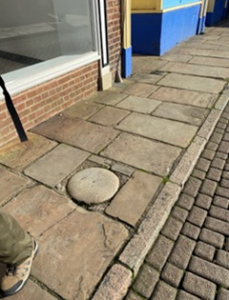 Boston is home to unique architectural features known as mud spots or mud stones. These granite stones, embedded in the pavement, date back to the 18th century and only their upper surfaces are visible at pavement level. It is believed that they were placed to mark the landowners’ responsibility for clearing silt from the River Witham to ensure navigation after the Grand Sluice opened in 1766. According to the Boston Preservation Trust, each stone weighs approximately 500 kg and measures 1.3 metres in length. Today, only two of these stones are visible above ground – both near St Botolph’s Church – mysterious relics of the town’s rich past.